This website uses different cookies. We use cookies to personalise content, provide social media features, and analyse traffic to our website. Some cookies are placed by third parties that appear on our pages. You can find more information and options to choose from in our Privacy Policy and Configurations for usage.
- Lesson plan
- Abstract
- Notes for the teacher
- Core question
- Objective
- Tasks
- Methods
- Equipment
- Agenda and timing of the stages
- Detailed lesson plan
- Part 1: Introduction / Knowledge update
- Part 2: Group work with sources
- I: Group work with photos
- II: Group work with maps
- III: Group work with a film clip
- IV: Group work with a primary source
- Part 3: Summary of the lesson
- Part 4: Individual reflection / Optional homework
- Appendices
- Appendix I: Working with video clips and photographs
- Appendix II: Glossary
- Appendix III: Handout 1
- Appendix IV: Handout 2
- Appendix V: Handout 3
Lesson Plan
Rainer Buitkamp Georg-Büchner-Gymnasium, Seelze, Germany / Paweł Dudek Zespół Szkół Ponadpodstawowych No, Radomsko, Poland / Lada Polunina State School No. 16, Perm, Russia / Elena Ushakova Gymnasium No. 3, Minsk, Belarus / Lesia Volokh Secondary School No. 1, Chornobay, Ukraine
13-16 years
45 minutes
Abstract
During this lesson, students will learn about the resettlement of the civilian population during WWII, get to grips with the distinctive features of forced labour (see Appendix II: Glossary) and the exploitation of young people, and understand how complex life became under these conditions. Students will analyse historical documents, maps, and statistical data. They will also study fictionalised accounts of forced labour in order to see how the topic is presented in popular media. There will then be a discussion, which will help the students understand, critically evaluate, and interpret the information they have analysed.
Notes for the teacher
-> During the lesson, the students will be expected to consider many types of source material. At this stage of their education they should be ready to work and draw conclusions not only from written texts but also from statistical sources, maps and visuals.
-> Teachers should remember to maintain momentum in the lesson, not dwelling too long on any one of the stages.
Core question
What was the difference between propaganda and the real life of young forced labourers during WWII?
Objective
To develop an understanding of the hardships associated with being forced to work in a place far away from home. To show and understand the different reasons people became forced labourers.
Tasks
-> Source analysis
-> Interpretations of contemporary film
Methods
Group work, brainstorming, debate/discussion
Equipment
Projector, computer, post-it notes, worksheets for group work.
Agenda and timing of the stages
| Part 1 | Part 2 | Part 3 | Part 4 |
|---|---|---|---|
| Introduction / Knowledge Update | Group Work with Sources | Summary of the lesson | Individual Reflection / Optional Homework |
| 5 minutes | 30 minutes | 5 minutes | 5 minutes |
Part 1: Introduction / Knowledge update
5 minutes
The lesson starts with a short exercise led by the teacher. The main goal of this exercise is to create an atmosphere of self-confidence.
The teacher points at the lesson topic which is already on the board - young people and forced labour during WWII - and asks: What kind of people are we going to talk about? The aim of the activity is to stress that this lesson is about young people, just like the students, who were unwillingly involved in the war.
The teacher then asks: What do you know about forced labour? Why might people have been forced to work during WWII? Students raise their hands and present their thoughts on the questions.
Teacher’s comment to the class:
Forced labour refers to carrying out work under the threat of some kind of potentially violent punishment. The Center for Documentation of Nazi Forced Labour in Schöneweide estimates that at least 26 million people from occupied countries were subjected to forced labour in Germany.
Part 2: Group work with sources
30 minutes
Teacher’s comment to the class:
During the war, Hitler’s Germany was faced with a workforce shortage. Millions of Germans were mobilized into the Wehrmacht (German army) and Germany was in dire need of manpower. The Nazis made up for the shortage by using slave and forced labour. The population of occupied European countries became a free labour force. There was widespread propaganda in these countries claiming that working for the occupiers would lead to a better life.
The teacher asks the students: What kind of questions might young people have asked themselves when they were leaving for Germany? After a short discussion based on this question, the teacher divides the class into three groups. Bear in mind that in a later exercise, Group 1 will receive the simpler task, and Group 3 the more advanced
I: Group work with photos
Each group works with the same three photos. The teacher informs the students that these are propaganda photos.
Questions:
- What do you see in the photographs?
- What do those photographs have in common?
- Why do you think they were taken?
- Is there any chance someone could believe what is shown in the photos?
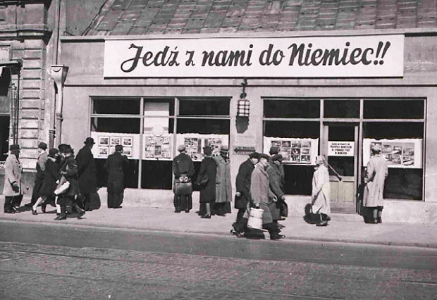
German propaganda photographs documenting recruitment for forced labour
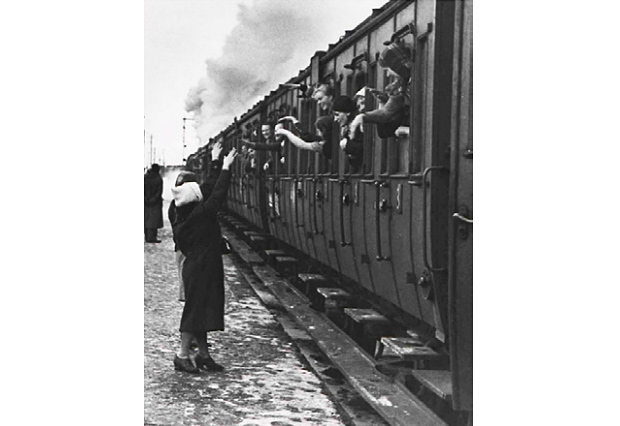
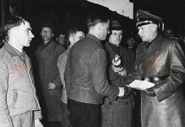
Photos: Unknown. Public domain: Western Institute in Poznan, WWII Archive, I.Z.Dok.IV-52.
The groups discuss the questions and then orally present their conclusions. The teacher should encourage students to listen to the other responses and try not to repeat things that have already been said.
Teacher’s comment to the class:
A variety of circumstances influenced young people to decide to go to Germany. Some were intimidated by the occupying authorities, some simply believed the propaganda, and some decided to take the risk. Many were taken to Germany by force. For the most part, civilians were taken away systematically during the first year and a half of the war, while in 1943 and 1944 people were taken during mass punitive actions, especially from partisan zones.
II: Group work with maps
All 3 groups work with the map at the same time but with different questions. The questions range from ‘easy’ (Group 1) to ‘the most challenging’ (Group 3).
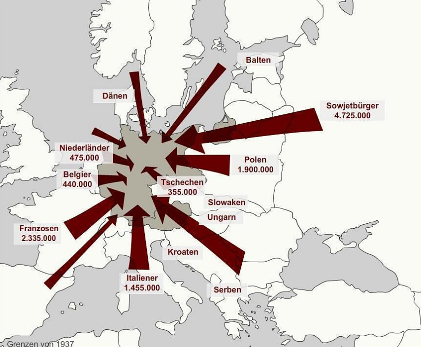
Map showing the countries of origin of forced labourers in Germany during WWII
Author: unknown.
Public domain: Zwangsarbeit-Archiv / Freie Universität Berlin.
Group 1
Name the countries and the number of people deported (see Appendix II: Glossary) to Germany for forced labour.
Group 2
Compare the directions of travel (north, south, west, east) and draw conclusions.
Group 3
What questions are not answered in this map?
After discussing in their groups, students orally present their findings from the map.
Teacher’s comment to the class (optional, if there is time):
The Generalplan Ost (see Appendix II: Glossary), developed in Nazi Germany before the attack on the Soviet Union, was monstrous in its inhumanity: the document provided for the extermination of entire groups of people. The same document defined the legal, economic and territorial basis for the transformation of Eastern Europe: the Nazis planned to move about 31 million people from the territory of Poland and the western part of the Soviet Union (Western Ukraine, Belarus, Lithuania, Latvia and Estonia) over the course of 30 years. They also planned to colonize and free up “living space” for Germans in the East, using inhumane methods to reduce the number of local people. Whole national groups were deported and forced to relocate far away from their native lands.
The people from the East who were forcibly sent to work in Germany were known as Ostarbeiters. Teenagers up to around 16 years old were the main target group, people over that age were generally taken in smaller numbers and were more frequently sent to concentration camps for extermination after they had been completely weakened and broken down. 30% of the Ostarbeiters were between the ages of 12 and 14. By November 1943, the age limit for the recruitment of Ostarbeiters was lowered to 10.
Source: The Borgen Project, 10 Facts about Nazi’s Germany Generalplan Ost, https://bit.ly/3z0OwCx (EN) and Звезда, Остарбайтеры, https://bit.ly/3qvRACI (RU), last visited 27.12.21
III: Group work with a film clip
The teacher shows the film clip about Walerian Wróbel, a 16-year-old Polish boy who worked on a farm near Bremen, Germany (see Appendix II: Glossary for a biography). The groups answer the questions based on the clip.
The Homesickness of Walerian Wróbel (1991), dir. Rolf Schuebel
Questions for the groups to analyze a fragment of the film:
Group 1
- Summarise what is happening in the scene.
- Describe where the action of the scene is taking place.
Group 2
- Describe the individual characters in the clip.
- Evaluate Walerian’s emotional state, his behaviour, and suggest what he may be thinking.
Group 3
- Paying attention to the clothes the main character in the film wears, the symbols on the clothes, the interior decorations, and the arrangement of objects in the house, identify what status Walerian Wróbel had. Pay close attention to the emotions of the people in the film.
- Why do you think the writers/filmmakers decided to make a film about Walerian?
After watching the film clip and discussing, each group presents their answers to the class.
IV: Group work with a primary source
(Optional, if there is time; can also be adapted and given as a homework exercise)
The teacher displays the document on the screen and gives each of the three groups a translation (see Appendix V). They should read through the document; the teacher should emphasise that the source relates to the boy from the film. Certain terms from the document will need explaining, in particular, the Nazi term “Volksschädling” (vermin, a harmful organism; a dehumanising term), as well as the term “der Gerechtigkeit freien Lauf zu lassen” (“to let justice run its course”).
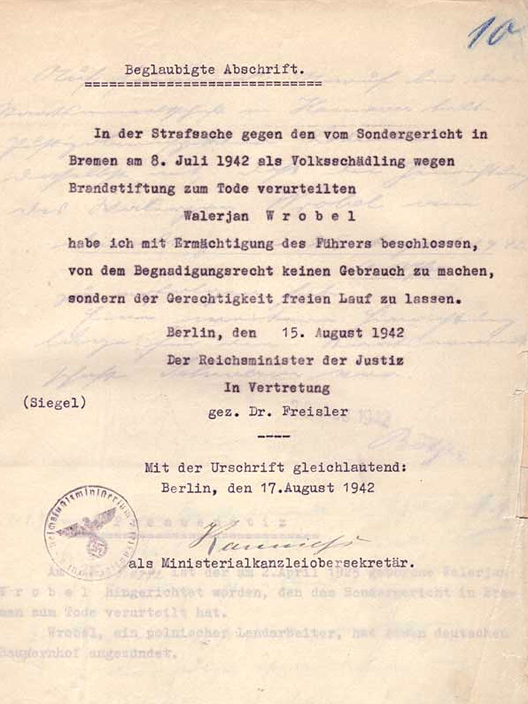
Official copy of the document recording the rejection of Walerian Wróbel’s petition for clemency, signed in the original by Roland Freisler, 15 August 1942.
Author: Reichsminister der Justiz. Public domain: Wikimedia
The teacher asks: What kind of conclusions may be drawn from the document?
Part 3: Summary of the lesson
5 minutes
Teacher’s summary to the class:
Forced labour exists even in the contemporary world, and understanding the past allows us to solve problems of the present and prevent them from recurring in the future. The fate of young people who were forced into Germany was tragic and full of oppression and repression, inflicted both by the occupiers and by their states. Many victims of German captivity testified that throughout their subsequent lives - after their return home - they were humiliated by others who accused them of living comfortably in the Third Reich during the war.
The teacher asks: What conclusions can we draw for ourselves from the information we learned in this lesson? A short discussion follows.
Teacher’s concluding words to the class:
Wherever they were born, lived, or worked, and whatever their nationality, every child, adolescent, and adult who fell under the “pressure” of forced labour has the right to be recognized by society as a victim of WWII.
Part 4: Individual reflection / Optional homework
5 minutes
The teacher asks: Did you fulfill the expectations you had of this lesson? Are you satisfied with yourself and your group? Students should reflect on their work and contribution.
Optional Homework Exercise: Motivated or interested students can watch video interviews with workers from different countries and, using the recollections of former young forced labourers, can prepare a short case study “What was it like to be a young forced labourer during WWII?”
The link to the website is here: www.zwangsarbeit-archiv.de/en/index.html
Appendix I: Working with video clips and photographs
Working with video clips and photographs
I. Methodological recommendations for working with film clips:
Film clips are resources which engage the viewer and can draw attention to historical problems; students can develop their analytical and interpretive abilities, and learn to listen and ask questions. Teachers can:
- Draw students’ attention to the story, to the characters, to the clothing, to the main character in the film, to the symbols on the clothing, to the interior furnishings, to the arrangement of objects in the house;
- Encourage students to observe carefully the emotions of the people in the film and try to evaluate the characters' actions, both the positives and negatives;
- Prompt students to identify the time period in which the events of the film take place;
- Invite the students to consider to what extent the events presented in the clip were true;
- Encourage the students to consider how the use of music affects their perception of the events in the clip.
II. Methodological recommendations for working with photographs:
The purpose of using photographical sources in education is to help students learn to analyse an image. Teachers should guide students towards:
- Starting with a simple photograph and moving on to more complex ones;
- Describing and analysing what and who is depicted in the photograph;
- Paying attention to the inscription and signs in the photograph, and the language they are in;
- Considering who might have taken the photograph, and why;
- Considering the objects that attract attention in the photograph;
- Thinking about what remains unknown in the photograph.
III. Key questions when analysing photographs:
- What does the photograph capture? Note the captions.
- What kind of people are depicted in the photograph? What is their relationship?
- When was the photograph taken?
- What purpose would the photograph serve (e.g., journalistic, sentimental)?
Appendix II: Glossary
- Forced labour in the Third Reich - performing work under the threat of some kind of punishment (potentially violent) during the existence of Nazi Germany.
- Deport, Deported, Deportation - the forced expulsion of a person or a whole category of persons to another state or another locality, usually under escort.
-
Generalplan Ost (GPO, Master Plan for the East) - an extensive programme for the consolidation of Third Reich rule in Eastern Europe, which provided for the forced removal of up to 75 - 85 percent of the population from the territory of Poland and the occupied regions of the USSR, and their placement in Western Siberia, the North Caucasus, and South America. This plan for the colonization and Germanization of the eastern territories was developed on the basis of the National Socialists’ racial doctrine, i.e. that of the Aryan ‘master race’ and other ‘races’ being seen as inferior, and the concept of "living space" (Lebensraum). Heinrich Himmler, Reichsführer of the SS and Reich Commissioner for the Consolidation of German Nationality (Reichskommissar für die Festigung deutschen Volkstums) was responsible for the eviction, resettlement and relocation in the East. The plan was to last for 30 years and was supposed to be launched after the victory of the Reich in the war against the Soviet Union. In 1943, its development was finally stopped.
Source: Wikipedia, Generalplan Ost, https://bit.ly/3ExB6zd, last visited 27.12.21
-
Walerian Wróbel (in Nazi documentation: Walerjan Wrobel; born 2 April 1925 in Falkowo; executed 25 August 1942 in Hamburg) was a Polish forced labourer executed by the Nazis at the age of 17. He was the eldest of three children and grew up on a farm in Falkow, Poland (in today's Świętokrzyskie Voivodeship). Shortly after his sixteenth birthday, in April 1941, he was taken by the German occupying forces and sent to Bremen to become an 'agricultural labourer'. On 19 April he was sent to a farm in the village of Lesum. Hoping that he would be sent home as punishment, he set fire to a pile of hay in the barn on 29 April. The fire was quickly spotted and put out, and caused no damage. Despite this, the incident was reported to the police. On 2 May, after an interrogation, he was arrested by the Gestapo. On 28 June he was sent to Neuengamme concentration camp where he was assigned to “Kommando Elbe”, meaning he spent the next nine months doing heavy labour, building a 600-metre-long canal between the camp and the Dove Elbe (a tributary of the Elbe). Prisoners had to work 12 hours a day in very harsh conditions, often waist-deep in mud, and many died of exhaustion. At this time, he befriended Michal Piotrowski, two years his senior, who recalled after the war: "Walerek was very young, very naive, and had no experience. So naive, that if you told him: this and this is true, or that in the camp so-and-so and so-and-so, he would immediately believe it. He believed everything. It was hard for such people in the camp, very hard. You had to be cruel there, not naive, and Valery was always naive, very naive. He was always talking about his parents, about his sister, about school.”
Source: Wikipedia, Walerian Wróbel, https://bit.ly/3qrdveu, last visited 27.12.21
Appendix IV: Handout 2
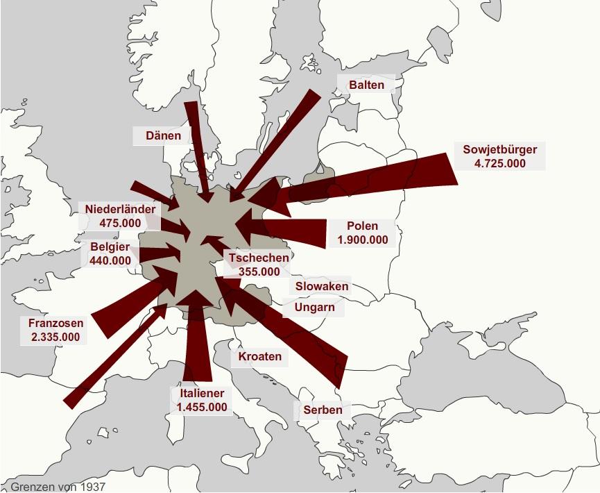
English translation (clockwise)
Balts, Soviet citizens, Poles, Czechs, Slovaks, Hungarians, Serbs, Croats, Italians, French, Belgians, Dutch, Danes.
Appendix V: Handout 3
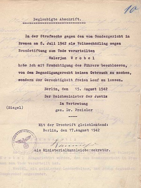
English translation:
Certified transcript
In the case against the Volksschädling sentenced to death for arson by the Special Court in Bremen on 8 July 1942.
Walerian Wróbel
With the authorization of the Führer, I have decided not to make use of the right of pardon, but to let justice run its course.
Berlin, 15 August 1942 The Reich Minister of Justice. Signed on behalf of Dr. Freisler
Other Lesson Materials
The beginning and end of World War II
Children in World War II
Remembrance and memorialisation of World War II in different countries
Border changes resulting from World War II
Consequences of World War II
Video: Clash of Memories


